In the first self guided tour I took you through all the essential spots in the city centre, Our second meander took you out to the North of the city so this time we are going to visit some spots on the ‘Southside’ As well as the usual essential items for any visit to Scotland you will need two more; a good pair of walking shoes and and a good pair of knees. this route will take you 7 miles, off the beaten track and up hills, down steps and even underground! are you ready? Lets go….
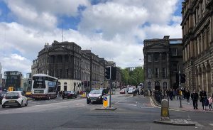
The Duke of Wellington’s equestrian statue at the East end of Princes St will be our start and finish point. The rather grand building behind him is the ‘General Register Office’, This building and New Register House behind it is where all of Scotland’s Birth Death and Marriage records are held. This is ‘ground zero’ for Scottish Genealogy. Its also a very busy part of town so let’s get going – look over to Wellington’s left and look for something that looks like the Parthenon and a tower that look like a telescope – this is where we are heading first. Cross the road (carefully) over onto Waterloo place. This was the end of our return route on the first tour. The Old Calton Cemetery is on the right, keep going till almost level with the corner of St Andrew’s House – a large imposing Deco style building. on the left you will see an entrance to Calton Hill, go through this and then turn right and head up the steps (there are going to be A LOT of steps on this route – feel free to count them and let me know how many)
The steps are the quickest route up onto Calton Hill, the other path is part of a network that wind slowly up the hill, the route depends on your energy level but if that’s an issue already then…. the bus tour is back the other way.. 🙂 The top of Calton hill is possibly the finest view over the city you will get. From the top of the steps you will see Dugald Stewart’s monument behind you looking out over Princes St for that iconic city view. Nelson’s monument on your right – a tower shaped like a telescope and the infamous National Monument is dead ahead. The Monument was intended as a war memorial to the fallen in the Napoleonic wars, The foundation stone was laid during George IV’s visit to Scotland that kicked off the whole tartan revival. The original plan was for a copy of the Parthenon with catacombs below for significant persons to be interred. The projected cost of this was £42,000 but nearly a year and a half into the project barely £16,000 had been raised so the project was abandoned and left as it is now. Interesting trivia alert… the builder who carried out the construction was called ‘William Wallace’.
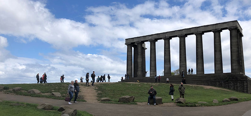
The other notable building up here is the City Observatory. This building has recently been renovated and now houses the Collective Gallery – one of the best spaces for showcasing emerging artists in Scotland, it also has a cafe!
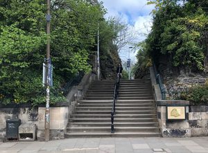
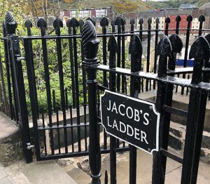
Head past to the right of the National monument and downhill, you will get some great views over to Arthurs Seat and the Crags so this is a good photo opportunity, follow the path downhill passing a large beacon and pick up the tarmac road that doubles back right and downhill back to street level, passing behind the former Royal High School building. The path emerges back onto Waterloo place by a small roundabout – cross over and go left a few yards and look for a gap in the metal railings with a sign for ‘Jacob’s Ladder’ – take this steep descent which worryingly looks like it is going to lead you directly onto the railway tracks below. Be thankful that you are going down and not up. Also be thankful you are not going up carrying (or even in) a coffin! Thats one reason these steps are here – this was the route up from the old town below up to Calton Cemetery so pall bearers would ascend Jacob’s Ladder with their heavy charge as the poor unfortunate soul made one last physical ascent before his final one (with luck).
These steps are just one of many shortcuts around the city and at one time were not for the feint hearted – they have since been restored and cleaned up though with some quirky lighting built into the handrails. The passage takes several small turns before plunging under the railway to emerge on Calton Rd in the gloom beneath the railway lines. Turn left and head down Calton Rd for about 150m and look for a cobble street going up to the right called ‘Old Tollbotth Wynd’. Cross over and take this path uphill under an arch and onto the High Street. This part of the old town hosts a couple of great little museums, The People’s Story museum just behind you in the old Toll Building and the Museum of Edinburgh over the road. I’m a big fan of both of these museums; they are both fascinating buildings with collections that cover the city’s social history – from the great and the good down to the city’s most impoverished souls. One heart wrenching display in the People’s Story museum depicts the living conditions of just one such poor individual. Its hard to believe that the buildings that survive today that may have housed the city’s poorest now change hands for millions of pounds.
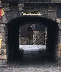
To the left of the Museum of Edinburgh look for an arch with a sign for ‘Bakehouse Close’. Fans of the Outlander TV series may recognise this as Carfax Close the home of the Printers where Jamie and Claire are reunited.
This is one of the best preserved old town closes in Edinburgh so gives a real sense of what the old city was like. The close was used many times to represent old Edinburgh streets in Outlander including the site of a brothel which is ironic as there once really was a brothel on this site in days long gone – known as the ‘Cock and Trumpet’. Carry on down Bakehouse close, the road bends left then right through a complex of more modern buildings before emerging onto Holyrood Road. Turn left and head downhill. This area has largely been redeveloped and was mostly the site of an old brewery and mostly derelict land. The former Scotsman Newspaper offices on the right are now the headquarters of Rockstar North. one of the worlds most successful computer games companies – a sign of Scotland’s incredible ingenuity in this sector. Keep going and you will pass the unusual structure of Dynamic Earth on the right – another excellent visitor attraction if you have time that will take you on a journey all the way back to the Big Bang! Keep to the left and take a passage that cuts through the New Scottish Parliament buildings to emerge onto the grassy terraces.
These terraces are part of the development of the parliament building. Rather than manicured lawns the terraces are sewn with natural wildflowers and have a much more rugged and rural feel – more fitting to Scotland’s natural landscape. The Parliament building and the Palace of Holyrood are over to your left and are both excellent places to visit and have been covered in earlier tours. Keep going ahead and cross over by the small roundabout with the car park for Holyrood Palace on your left. just by the car park entrance you will spot a tarmac footpath heading gently uphill on the right, take this path to enter Holyrood park proper. This tarmac path curves gently right and continues uphill. A signpost has been recently added pointing the route to Arthur’s Seat going left but just ignore this and stay on this path.
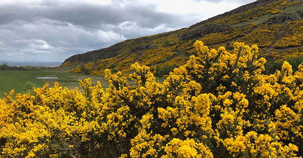
If you are fortunate to choose this walk on a quiet day then you have the privilege of leaving the city behind and wandering into the vast arena between Arthur’s Seat on the left and the Crags on your right. on a bright spring day with the gorse in full bloom the golden yellow colours spreads like dappled sunlight over the hills, car engines are replaced by the sound of nesting birds and you could be on a rugged path through a highland glen rather than the centre of a city. There are as many stories about Holyrood park that would easily fill a series of blogs so lets settle ourselves with one interesting tale;
In 1836 two boys were out hunting rabbits on a less explored area on the Northeast side of the hill, there they discovered a small cave and inside the cave – partially buried they discovered 17 miniature coffins – each with a perfectly – made doll inside. To this day their purpose is a mystery, one theory links them to the victims of the notorious Burke & Hare, matching their 17 victims – other theories link them to use in Witchcraft – a popular theory as it was well known that such rituals took place in the park. Another recent theory is that the coffins are linked to the martyrs of the Radical War – many of those involved were set to work building the ‘Radical road’ around Arthur’s seat. Some of the best preserved coffins are on display at the National Museum on Chamber’s Street where you can make your own mind up about them.
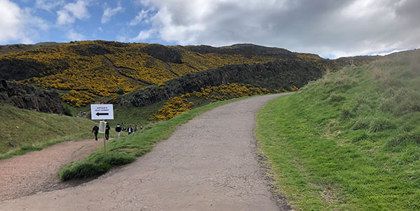
The tarmac path soon turns into a rougher path, passing ‘Hunters Bog’ on the left before climbing up to a junction of paths by some boulders. Here I will give you a choice of routes; either via the top of Arthur’s Seat or alternatively walking along the road by Queens Drive.
Option 1 – Up and Over:
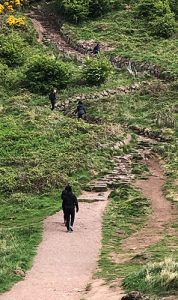
When you get to the top of the path look over to your left, you will see a track leading to some rough steps that zig zag up the side of the hill. make your way carefully ups these, taking care if its wet and also watching out for other users – the hill can be busy at popular times. Eventually it straightens out and heads away from the summit for a bit then you can double back towards the top. The path leads to an open grassy area strewn with stones (recently people have been getting into the habit of arranging these to spell names or stacking them. Head slightly downhill through a shallow grassy valley till you come to another junction by some bushes – there’s a well worn path on the left that leads to the top of the hill. If in doubt follow the thousand other people doing the same thing! Take care as you near the top – this is a popular spot and the rocks have been worn smooth over the years. Its not uncommon for accidents to happen and the only way off from here with a broken leg is by helicopter.
The view from here is pretty much as you would expect, over to the west you can easily spot the Castle – further on you can make out the Bridges over the River Forth and on a clear day you can make out Ben Lomond all the way over towards the West of Scotland. To your North you can see across to Fife with more distinctive volcanic peaks. over to the south the Northern most parts of the Pentland hills are clear.
Trace the same route back to the junction but continue on down the hill following a grassy slope heading towards a small loch. At the road look for a small car park to the right of the loch and just beyond this you can make your way downhill with a high wall on your left – this area narrows until an exit is reached with some stone steps taking you down into Duddingston Village.
Option 2 – Queens Drive
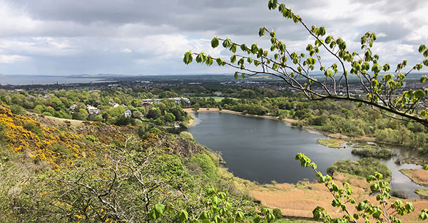
At the head of the path turn right and over the small pass, head downhill to the road and take the first road heading left uphill – its a narrow one way road with a path on the right side. carry on along this road as it winds around the red volcanic rocks of Arthurs Seat. There are great views over the city to the south from here, Duddingston Loch, a popular bird sanctuary lies below. In the large complex of modern buildings on your right that form the halls of residence for Edinburgh University you will see one crazy looking baronial house, This is Pollock House, formerly the School of St Trinians that was the inspiration of the series of books of the same name. The rather grand house set in the grounds of a golf course is Prestonfield House at 17th century mansion. If you look beyond this further into the distance to fields the other side of the New Royal Infirmary you can just about make out Craigmillar Castle. This was used extensively in the filming of the recent Outlaw King movie. This untaxing gentle walk continues round the hill. When the railings on your right end you will see a path heading downhill – take this to where the path meets the high wall on its left to pick up the steps leading down into Duddingston Village.
Reunited:
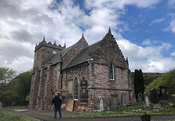
We are now both on the same path now whether you took the high road or the low road. A long broad flight of steps leads down to the roadway coming out just at the entrance to Duddingston village. if you cross the road there is an entrance that will take you down to the lochside if you want to explore this. Back on the road head into the village, immediately on your right is the entrance to Duddingston Kirk. This Norman style church was first build in 1124 by Dodin a Norman knight. The triple stained glass window on the north side has an American connection; is is dedicated to Joan Carfrae who was the wife of Alan Pinkerton the famous American Detective.
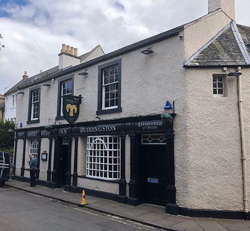
After having a good explore around the church it’s probably time for a rest stop – so let’s go to Scotland’s oldest surviving rest stop! Come out of the churchyard and cross the road up a small lane on the other side, your nose should guide you the remaining few yards as the road bends sharply right to reveal the Sheep Heid Inn on the corner. There has been an inn on this site since 1360 making it the oldest surviving public house in Scotland – most of the standing building was constructed in the 18th century which is still pretty old though. The inn reputedly gets its name from the fact that sheep used to graze on Holyrood park and the main slaughterhouse was in Duddingston – the locals became quite adept at making use of the leftovers from the sheep (the heads) and the village became well known for its culinary ingenuity. The pub also features a skittle (bowling) alley dating back to 1880 the last of its type in Scotland. Lying halfway between the city and Craigmillar castle the inn was frequented by the likes of Mary Queen of Scots when she resided at Craigmillar. Bonny Prince Charlie also camped near here before the Battle of Prestonpans.
The inn does excellent food and a good range of beers and seems surprisingly tolerant of all sorts of tourists with lots of nooks and crannys to snuggle into. if you have timed this walk well it might be lunchtime (if you need an excuse) there’s still a lot of walking to do.
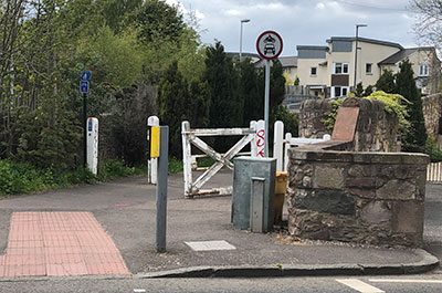
After a reviving break head back to the roadway and continue through the village – its a very pretty village with well set out gardens, If you are lucky Dr Neil’s garden may be open on the right side as you pass through – this is a lovely ornate garden around a small pond. At the junction at the end of the road through the village turn right and take this road for about 700m passing the newly build Holyrood High School on the left and then over a small burn. At a pedestrian crossing look or the white gateposts on the right leading to the entrance to the Innocent Railway. Take this path.
The Innocent Railway was originally a horse drawn railway line that conveyed coal from the mine workings at Dalkieth to the marshalling yards at St Leonards where it was then distributed across the city. The line was operating on the 1830s and soon became used for passengers as well as freight. The term Innocent Railway is supposed to come from the claim that no man or animal was injured in all the years of the line’s operation (which isn’t strictly true but it makes a nice story) The risk of injury today on this path is most likely from cyclists (Edinburgh cyclists have yet to discover the bell) so just be aware as you wander along this stretch of the route. The path is bound by high walls on both sides but there’s an abundance of wildflowers on the route and the scent of wild garlic is strong in patches – again its a pleasant enough walk and nice to be away from traffic.
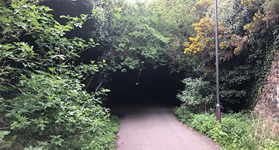
As you continue along the path you will soon be aware of the rounded bulk of Arthur’s Seat over to your right, looking dead ahead the path seems to disappear into the vegetation, swallowed up into a dark and slightly worrying hole. Its time to remember that you are on a 19th century railway line and you can’t have a railway line without… .tunnels…
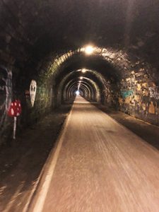
The Innocent railway tunnel can be quite unnerving if alone or of a certain disposition. On a bright day you can be suddenly plunged into darkness – there is lighting but it takes a while for your eyes to get used to it – the exit is a little over 500m away and seems to take a long time before you exit the other end. The tunnel is naturally a magnet for graffiti but during the summer there are enough walkers and cyclists to make you feel comfortable. If you really don’t fancy the tunnel there is a path up onto the road you can follow. Finally the tunnel opens up into the lower level of a rather dull modern complex of apartments – just keep going through these blocks following the cycle path signs for ‘The Meadows’ untill the road bends left at Hermits Croft. You will emerge onto a main road at St Leonard’s St, cross over then go left and then right into Bernard Terrace just by Nelson Hall (there is a useful information board on the side of Nelson Hall pointing out some local landmarks if you want to explore this area more – or save for another day – the excellent Surgeons Hall Museum is very close by).
Continue straight and cross the busy junction onto Hope Park Terrace and cross over again at the end of this street the sprawling open parkland of The Meadows now opens up in front of you. The road passes through between two pillars with a Lion and one with a Unicorn on top of the other. the main park area is on your right. This is the largest open park area on the South Central part of the city and is in the heart off the student district so on any day that is not classified as ‘Baltic’ the park will be full of locals, playing sports, relaxing, or just enjoying the space. There always seems to be something going on – the space gets used a lot during the festival and there are regular markets along the many paths through the park.
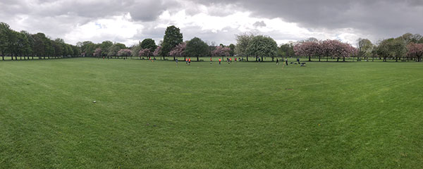
The park was once a large loch known as the Burgh Loch where the city’s main drinking water supply was drawn from up until the 1620s when the first piped water supplies were fed in. After this the loch was drained and filled in and trees planted to improve the area – there is a ban on permanent building in the park so it’s free to be enjoyed by all. The paths all radiate out from one point on the North side so make your way here – path names give some clue to the past history of the area; Archers Walk relates to the Royal Company of Archers who headquartered nearby and Jawbone Walk relates to the whale jawbone arch that once stood at the far end of this path until a few years ago.
Where the paths converge one larger path heads north out of the park gently uphill – take this route back towards the city. At the end cross over and keep going straight. If you passed up the chance for a drink in the Sheep Heid then keep an eye out for Sandy Bells on the left – this is a ‘proper’ Edinburgh pub that regularly has local folk musicians playing and is a great place to have a swift one before heading on.
A few yards further on you will no doubt come across a knot of tourists up ahead all stretching out to rub the nose of a dog statue – yes its Greyfriars Bobby. I’m not going to get into the whole ‘nose rubbing’ thing but if you want to look like a tourist who falls for any scam going then rub away! Greyfriars Kirk, as previously covered is on your left and the National Museum (also covered) in over the road on the right (why not go in and look for those coffins we spoke about earlier – clue: they are in the modern part of the building). Another trivia alert…. if you look down Chambers Street where the museum now stands, this was once the site of the Kirk o Fields. A former Collegiate Church. On the 10th of February 1567 this was the site of the murder of Lord Darnley, the husband of Mary, Queen of Scots.
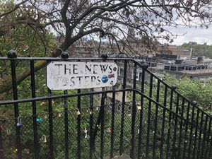
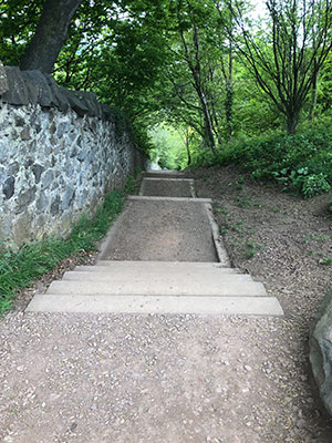
Carry on straight ahead along George IV bridge back towards the High St. At the junction cross over diagonally to the right corner and go around behind the large building (the High Court) St Giles Cathedral is just over your right shoulder. take the lane ahead of you into the corner. You know what you haven’t had for a while? STEPS! One last helping of Steps now lies ahead. The News Steps is a shortcut down to the lower street level, after 7 miles of walking I’ll be honest I felt this one.
At the bottom cross over and up Waverly Bridge, the Castle is over on your left and the Scott Monument dead ahead, once onto Princes Street turn right and trace the route back to the start.
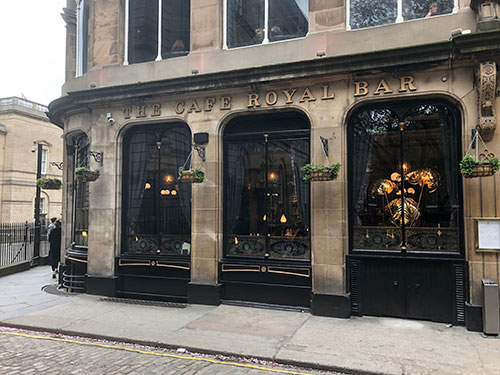
This route took me around 3 hours with one short stop so you can easily make a full day of it with a few stops and detours. If you have just finished and you are back next to Wellington’s statue then one last treat – take the lane up the left side of Register House, past the Guildford Arms and round the corner to the Cafe Royal. A magnificent Victorian pub with lovely comfy leather booths, interesting decor and a not bad restaurant upstairs. The perfect place to uncurl your toes relax and have a scroll through the photos on your phone 🙂